Komoot Is Pure Magic For Trail Running
Excellent green space focused maps, navigation to die for and a social highlights system for local discovery

Up until recently I've only ever used Strava to track runs and plan routes. As a tool is has done me well and I continue to use it for recording, performance and goals.
It also has some useful route generation features, such as recommending routes based on the most popular areas nearby based on other user's activity, alongside showing a global heatmap of where's most heavily run.
However, when it comes to trail running in particular, Strava does fall a bit flat. It starts with what Strava choose to focus on in their maps, let's look at a local woodland as an example:
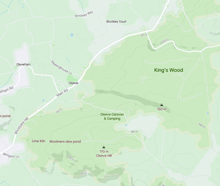
At this zoom level, Strava only shows the roads and lanes, with a few labels over points of interests such as peaks and the pond.
Through both the north and south woodlands shown there are a multitude of trails, as there are in the fields north west of Cleeve. Strava also has this information, if you zoom in far enough those trails start to appear, however they aren't clear, and won't show when you are scouting around trying to determine where may be best to plan a route.
I've also noticed in the app that when actively following a route, you lose a lot of that granularity too. Often I've got lost in a woods, opened Strava to check which trails I could take to return to the route, and found it showing me a rather large blank green area with no detail.
Now let's look at the same area on Komoot:
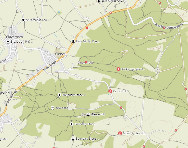
Note that at the same zoom level we have a crystal clear view of all the trails through this woodland; and the maps colour scheme makes them prominent, rather than bleeding into the background. In addition, the clarity around the tree-lines is better and we are able to see which roads are main vs lane vs farm roads.
It's for this reason I started playing with Komoot for my adventures.
What Is Komoot
Komoot is an app and website designed to help plan and share routes for cyclists, hikers and runners. It's main features are:
- A Social Feed, showing lists of local routes, collections of interesting hikes / rides / runs and people to follow. This helps with discovery and inspiration
- The Route Planner, a tool that works on both the apps and website for plotting a route, with useful features like being able to reverse the direction, change where the route starts and reposition points
- Tours, which are the list of routes you've either created or bookmarked, grouped by those you've planned and those you've completed
- Navigation, allows you to track where you are on a route, download the maps so they can be used in aeroplane mode and notably gives you directions back to the route if you get lost
- Highlights are points of interest or sections of trails other users have marked as of special interest; whether that's a particularly nice viewpoint, an interesting village or a gnarly technical trail
- Pioneers are users who have made lots of contributions (in terms of highlights, photos and votes) to a given region, it's a way of rewarding and highlighting those making the platform better
- Collections are ways of grouping lots of tours together, often used for multi-day tours, or lists of interesting local places to explore
Why Do I Love It?
There's a few features that make it, in my opinion, stand out from the crowd for trail runners.
Firstly, as show above, the maps they generate are super clear and clearly geared towards exploration of green spaces. The detail around tree lines, types of road and tracks is hard to overstate, they even map where stiles are for you!
This is made more useful with their Route Planner which allows you to select points you'd like to get to, then intelligently follows trails and lanes to get you there. I've yet to find a generated route from Komoot that wasn't ideal or took me along an inappropriate route (I've done routes in other apps along 60mph roads with no verge that weren't exactly fun).
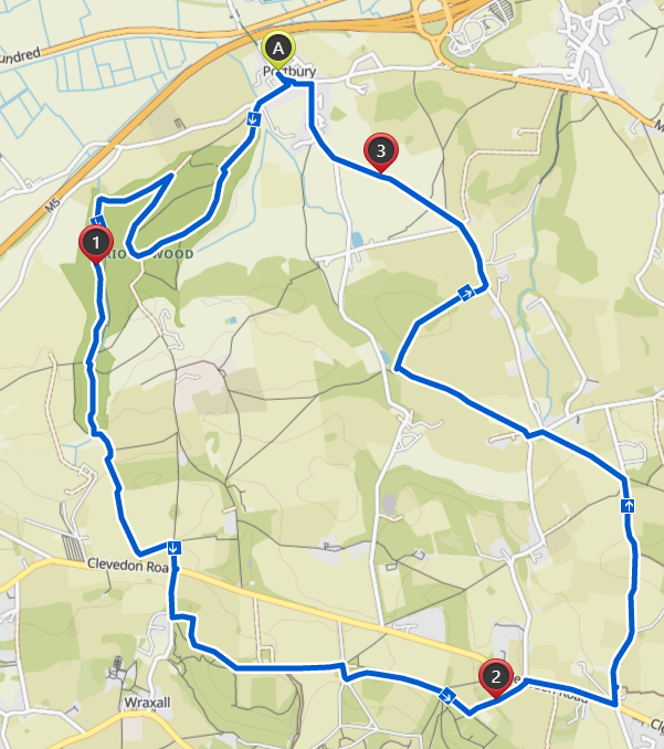
In the above example trail run tour; I've said I want to go to Prior's Wood, Tyntesfield then follow a lane back to the car in the east. The rest was generated for me by Komoot, and without me telling it to it followed mainly footpaths through fields and woodlands, going on to quiet lanes where it had to.
The next cracking feature is the Highlights system which allows users to mark areas of interest, as show by the red blips below
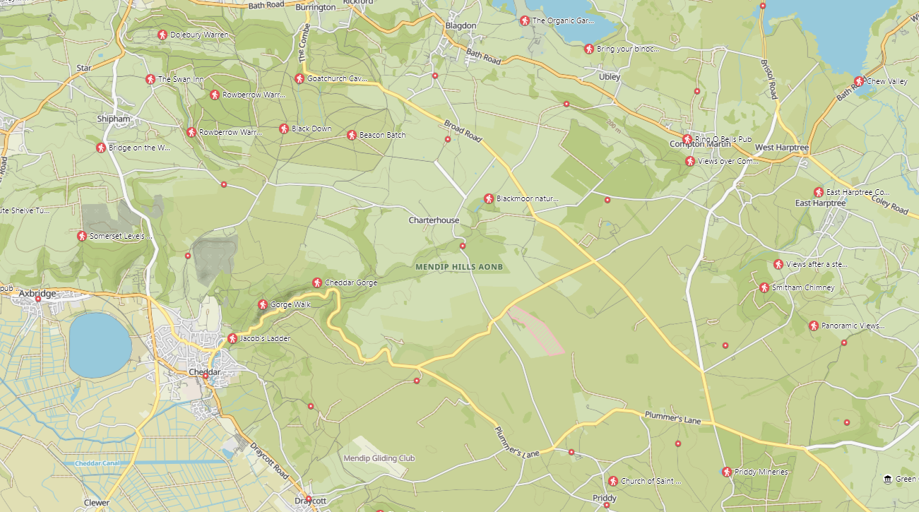
These are the hiking highlights for the Mendips, with highlights for other sports being the smaller dots. When using the Route Planner you can select highlights to add to the route, and it will generate a tour that navigates trails to hit each highlight.
Each highlight can have photos, tips and votes from other users, really helping you discover interesting places in your local area.
Once you've completed a tour in the app, you can add your own highlights or contribute photos to those you visited along the way. One thing I really like here is that you can only generate a highlight from a tour you've done, so if you remember a nice viewpoint from a previous run, but haven't done it on Komoot yet, you're encouraged to go capture it.
The final big one for me is the Navigation in the app; and oh boy is it a good'un.
There's a few things navigation does well I've found lacking in other apps:
- The compass tracking is pretty bang on, using direction of travel for a more accurate reading (especially good with my Android's horrendously out of whack compass.
- By default the app stays on without needing you to unlock your phone, making it easier to quickly check where you are when wearing gloves
- Maps can be stored offline which, combined with aeroplane mode, give you much more battery life and confidence on longer routes
- The detail on the maps helps with navigation, tree-lines, stile positions etc all aid in zoning in on where you are
- If you go off route a dotted line displays showing you the direction to get back to the tour, especially useful if a way is unexpectedly blocked and you need to find an alternative way round
- Highlights are saved, even in offline mode, so you can choose to make detours as you are passing a point of interest
What Would Make Komoot Even Better
Despite all the good, there's still a few things I think would help improve the platform further
- Multi-Sport Highlights - Currently highlights appear to be tied to a single type of sport, whilst many can be enjoyed by a range of sports. For example a viewpoint atop the Mendips is likely something both hikers and runners can enjoy, but may be too difficult for road cyclists to get to on bike
- Better Highlight Contribution UI - When finishing a tour, you are asked if you want to create highlights from the route. It can be difficult to see whether the highlight you are creating is a duplicate of another as the create highlight UI doesn't show community highlights to contribute to
- Route Planner performance - I've noticed a few stutters and slowdowns when using the planner, even on a fast device., though appreciated it is often rendering a LOT of map data and generating routes.
- Polar Integration - Garmin appear to have first class support with Komoot and you can sync both tours and completed routes from a Garmin watch. It would be good to have the same available for Polar. Appreciated this likely requires work on Polar's side to enable the support, currently I use the watch to sync the completed run to Strava, and my phone to complete a tour on Komoot
- Heatmaps - Being able to see where you've been across all completed tours would certainly be rewarding, and show areas you've yet to explore in a region